In 1946, the Louisville Board of Alderman passed an ordinance proposing to annex St. Matthews’ business district. This was viewed as an attempt to grab the revenue-producing business section without having to provide city services to the thousands of people living in the nearby residential areas. (At the time, St. Matthews was believed to be the most populous unincorporated community in the United States.) When business owners in the affected area went to court to block the annexation, Louisville passed a second ordinance, proposing annexation of the residential areas as well. The state Court of Appeals ruled against the annexation in 1950.
On March 22 of that year, St. Matthews was incorporated as a sixth-class city. Initially it consisted of only three square blocks, bounded by Westport Rd, Gilman Ave, Chenoweth Ln., and St. Matthews Ave. The very next day, however, the city’s council passed an ordinance proposing to annex the entire St. Matthews Sanitation District No. 1, an area with a population of about 15,000 residents. That move was quickly challenged by an anti-annexation group, whose lawsuit was eventually sustained by the Court of Appeals, limiting St. Matthews to its original boundaries.
Over the next four years, Louisville ( which had coveted St. Matthews territory as early as 1940), tried on three occasions to pass legislation making it easier to annex unincorporated territory and sixth-class cities, but was unsuccessful each time. Louisville also passed six additional ordinances proposing to annex parts of St. Matthews, all strenuously opposed by the St. Matthews Annexation Protective Association, a business owners’ group. Nonetheless, two of those efforts succeeded. Ironically, one of the areas claimed by Louisville was the original St. Matthews business district near ‘the Point.’
When the smoke cleared, St. Matthews comprised two areas that were home to about 6,500 people who had voted to accept annexation into the new city. One area was bounded by the city of Bellewood, Frankfort Ave, Windy Hills and Chenoweth Ln, the other by Shelbyville Rd, Norbourne Blvd, Eline Ave. and Browns Ln. St. Matthews became a fourth-class city in June 1954.
For fiscal 1954, the city had receipts of $48,965 and spent $34,216, including $1,442 for police department salaries and $17,673 for public works (mainly road construction and repair and garbage collection).
St. Matthews Sanitation District No. 1 had been formed in 1945 to work toward providing sewer services for the poorly drained area, which was known to some as the ‘land of the lakes’ because so many streets flooded after brief summer rain showers.
The sewer system initially was expected to cost $1 million, but ultimately cost $2.75 million, because the start of construction was delayed for nearly five years and because the construction companies unexpectedly struck rock. Two firms that helped build the system went bankrupt.
The city’s first ‘city hall’ was Mayor James Noland’s home on Kennison Ave. Subsequently, city offices were located in the former Post Office Building at Willis Ave. and Breckenridge Ln; then in the Colonial Building on Breckenridge Ln. which had to be vacated after being annexed by Louisville; then in the store front near the present site of Trinity High School; and later, in 1960, in a new City Hall built just east of Thierman Ln. That building with just 5,500 square feet of usable space was eventually outgrown, and in 1994, a new City Hall was established at 3940 Grandview Ave. in the 30,000 square-foot, former Greathouse Elementary School building, which the city purchased for $1.3 million and renovated at a cost of more than $1 million.
The Grandview Avenue building presently houses city government offices, the police department, the St. Matthews/Eline branch of the Louisville Free Public Library and office and meeting space for such groups as the Chamber of St. Matthews and the St. Matthews Beargrass Historical Society.
The St. Matthews Flag Story
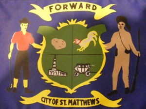
St. Matthew’s flag is emblazoned with symbols of the community’s history: a buckskin-clad pioneer who represents the explorers who first settled in the area; a potato and a hoe-wielding farmer, exhibiting St. Matthews’ heritage as a producer and marketer of potatoes and other vegetables; a stagecoach, for the coach stops that were the area’s first businesses; a fighting cock, for a “sport” that was popular in St. Mathews early in its history; and a church, representing St. Matthews Episcopal, for which the city was named. The flag is primarily blue and gold, the colors of the Commonwealth of Kentucky, with green to represent the fertility of the area’s soil. It bears the one-word motto, “Forward.”
The flag was designed in 1960 by Stephanie Baldyga, then a 13-year-old eight-grader at Our Lady of Lourdes School, the winner of a flag design contest sponsored by the St. Matthews Elks Lodge. Six civic organizations donated a total of $212 to have the first flag made.