 Colonel John Floyd, a surveyor and pioneer from Virginia, apparently was among the first to make his home on the high, fertile ground of present-day St. Matthews. He arrived in the thickly forested area along the middle fork of Beargrass Creek in 1779, just one year after George Rogers Clark erected the Corn Island fort that would eventually become Louisville. Floyd lent his name to one of the earliest crude fortifications in the area, Floyds Station, and was among the builders of Spring Country Club. He was killed by Indians in 1783 and buried new the present site of Jamestown of St. Matthews apartments, off Breckenridge Lane.
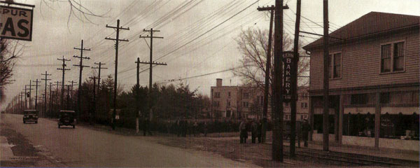
In the early 1800s the sparsely populated area was called Sale’s Precinct, for Captain Edmund P. Sales, who owned a tavern on the primitive stagecoach route that linked Louisville and Frankfort Kentucky. Traffic picked up in 1832 with the completion of the Shelbyville Turnpike, and hard-packed gravel road from which passing wagons lifted powdery clouds of limestone dust, and again in 1851, with the opening of a Louisville-Frankfort rail line. By then the area had long been known as Gilman’s Station, Gilman’s Point, or simply Gilman’s- for Daniel Gilman, another tavern owner, who located his business at “ The Point”, the juncture of Shelbyville and Westport Roads, Breckenridge and Chenoweth Lanes, and Frankfort Avenue – the site of the community’s original business district.
 Around 1850, some citizens arguing that it was unseemly for their settlement to share the name of a saloon keeper, began calling it St. Matthews, borrowing the name from the area’s first church, St. Matthews Episcopal, which had recently been built on what is now St. Matthews Avenue. The name became official in 1851 when it was adopted by the newly established post office, although the railroad stop was still known officially as Gilman’s Point, and the Gilman name continued to appear on maps as late as 1879.
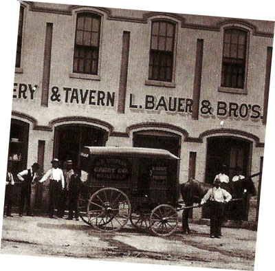
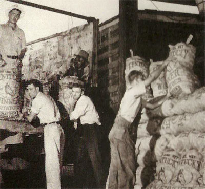
Through most of its history, St. Matthews was a community of large farms, many of them originally owned by pioneer families who names are still familiar today – among them Brown, Rudy, Chenoweth, Massie, Monohan, Bullitt, Nanz, Aterburn and Breckinridge ( Breckenridge Lane was named for pioneer Alexander Breckinridge, but is spelled differently today because of an error compounded by a succession of street-sign painters). Farmers who managed to reclaim the swamp land that lay generally between Shelbyville and Brownsboro Roads discovered that it was ideal for cultivating root vegetables, especially potatoes and onions. The prosperity that ensued was enhanced by St. Matthews’ ideal location along the tracks of the Louisville, Lexington & Cincinnati Railroad, which provided ready access to northern and southern markets alike.
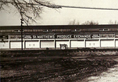
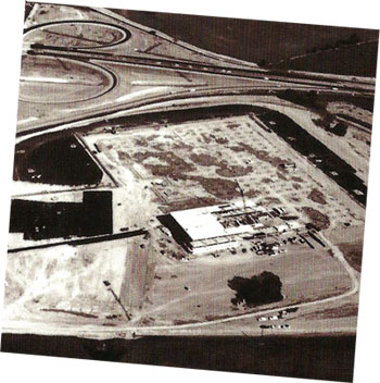
The St. Matthews Produce Exchange, formed by 200 farmers in 1910, grew to become the second-largest potato shipper in the world. Stock in the venture initially sold for $5 a share; by 1921, when more than 13 million pounds of potatoes were dispatched by rail from the Exchange to all parts of North America, a share was worth $75. St. Matthews was known as “the potato capital of the world” until 1946, when the Exchange closed its doors. The hangar-like Exchange facility, which included” a frost-proof building for the storage of 10,000 barrels of second-crop potatoes,” survives as The Colony shopping center at Westport Road and Clover Lane.
 Eventually, as land in the area become more valuable for development, most of the old family holdings were broken up and subdivided. The process got under way in 1907, when Henry and Emma Koehler split their property on St. Matthew Avenue (between Westport and Shelbyville roads) into 25 residential lots. The first big housing boom came in the late 1920s ( when the going price for prime land reached $3,000 per acre). That period was followed by the bust known as the Great Depression (when landowners dropped their prices to as low as $300 per acre, and still had not takers). A second boom started just after the 1937 flood and lasted until the attack on Pearl Harbor. After a wartime lull, the last great boom started in 1946. As the area’s population grew, a modern shopping district developed along Lexington Road, near the present site of the now Vogue Center. Virtually all of the available improved land in the area was developed by 1950, when St. Matthews officially became a city.